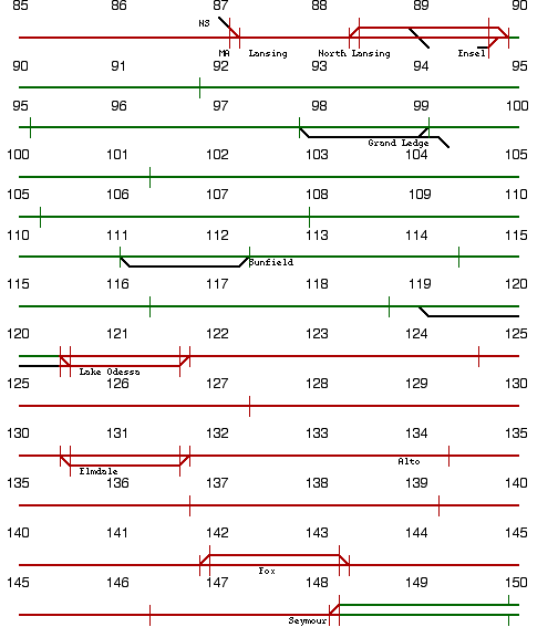
Route west of Grand Ledge originally was constructed to Ionia, prior to construction of line serving Grand Rapids.
Radio Frequency - 160.230 (AAR Channel 08)
Dispatcher (Grand Rapids-Plymouth) - 160.320 (AAR Channel 14)
Dispatcher (Plymouth-Detroit) - 161.370 (AAR Channel 84)
ITALICS INDICATE ABANDONED SEGMENTS
152.9 Plaster Creek (Grand Rapids)
151.7 Sunnyside
151.3 Pleasant Street
148.1 Seymour
142.5 Fox
133.9 Alto
130.4 Elmdale
120.1 Lake Odessa
112.2 Sunfield
99.3 Grand Ledge
89.9 Ensel
88.3 North Lansing
87.4 Lansing
87.2 MA
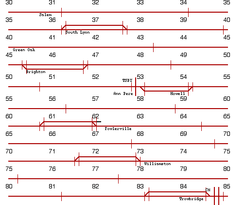
84.8 Trowbridge (CN crossing)
73.4 Williamston
62.5 Fowlerville
54.2 Howell
52.9 Ann Pere (GLC crossing)
45.2 Brighton
40.0 Green Oak
36.1 South Lyon
30.9 Salem
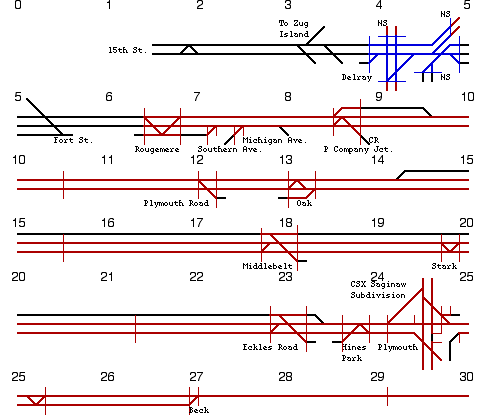
27.0 Beck
24.5 Plymouth
24.1 Hines Park
23.0 Eckles Road
20.0 Stark
17.9 Middlebelt
13.2 Oak
12.1 Plymouth Road
8.7 P Company Jct.
7.7 Michigan Ave.
7.5 Michigan Ave. Conn.
7.2 Southern Ave.
6.6 Rougemere
5.5 Fort St.
4.5 Delray
1.0 Detroit 15th St.
0.0 Detroit 6th St.
1 track, CTC in use. Between Sunnyside and Seymour, 2 tracks, signaled for normal right hand operation. Between Lake Odessa and Ensel, 1 track, Direct Traffic Control in use with automatic block signals. Controlled by CSX "RN" Dispatcher in Calumet City.
Between Grand Rapids and Seymour, line is part of Grand Rapids Terminal Subdivision. Between Plymouth and Detroit, line is part of Detroit Subdivision.
Information is based on a 1995 CSX track chart, verified in 2013 using Google satellite imagery, and is subject to change.